As I Trout Bum around North America I come across some wonderful water.
Under construction
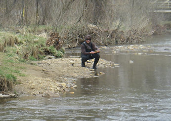
Lehigh River, Pennsylvania

https://en.wikipedia.org/wiki/Lehigh_River
The Lehigh River, designated a Pennsylvania Scenic River , is, 109 mile long, and is the largest tributary of the Delaware River
"Lehigh" is an Anglicization of the Lenape name for the river, Lechewuekink, meaning "where there are forks".
The river flows in a highly winding course through valleys between ridges of the Appalachian Mountains. Its upper course is characterized by numerous whitewater rapids and supports a broad range of recreational pursuits including whitewater rafting, kayaking and canoeing.
Blessed with numerous scenic tributaries…

The area below the dam provides a slippery reason for even the most sure footed angler to use a wading staff.

Its lower course…

...forms the heart of the Lehigh Valley, a historically important anthracite coal and steel-producing region of Pennsylvania. where it is joined by Little Lehigh Creek, then northeast past Bethlehem, where it joins the Delaware River in Easton, along Pennsylvania's border with New Jersey.
The Lehigh River holds many species of fish, such as trout, smallmouth bass, largemouth bass, pickerel, panfish, carp, catfish and muskellunge (muskie).
Browns and Rainbows can be caught in the 18"-20" range, some have been caught into the mid to upper 20" range.
Smallmouth bass plentiful between 8"-14" with an occasional fish from the 18"-21" range and pure and tiger muskie in the 30"-52" range.
The Lehigh Coldwater Fishery Alliance and the Pennsylvania Fish & Boat Commission have worked with the Army Corps of Engineers to design annual flow plans[2] from the Frances Walter dam maximizing he cold water discharge through the spring and summer enhancing the population of Brown Trout,
The following groups stock the river with trout.
-
Pennsylvania Fish & Boat Commission - Stocking F.E.W. to Sandy Run Creek, and Glenn Onoko to Jim thorpe
-
The Lehigh River Stocking Associations - Private Stocking Club - Stocking Glenn Onoko to Northamption
-
The Five Mile Club - Private stocking club - Stocking Bear Creek to Glen Onoko
The Lehigh River is a white water river with Class I, II, and III rapids. through the Lehigh Gorge State Park.[4]
The following links are useful.
wading anglers will find good access at Tannery Bridge, Glen Anoka and Treichlers bridge
Big Horn River, Montana
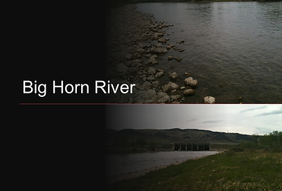
The Wyoming and Montana’s 461 mile long Bighorn River is a tributary of the Yellowstone
The river was named in 1805 by fur trader François Larocque for the bighorn sheep he saw along its banks as he explored the Yellowstone.
The upper reaches of the Bighorn, south of the Owl Creek Mountains in Wyoming, are known as the Wind River. The two rivers are sometimes referred to as the Wind/Bighorn. The Wind River officially becomes the Bighorn River at the Wedding of the Waters, on the north side of the Wind River Canyon near the town of Thermopolis. From there, the river flows through the Bighorn Basin in north central Wyoming, passing through Thermopolis and Hot Springs State Park.
At the border with Montana, the river turns northeast, and flows past the north end of the Bighorn Mountains, through the Crow Indian Reservation, where the Yellowtail Dam forms the Bighorn Lake reservoir. The reservoir and the surrounding canyon are part of the Bighorn Canyon National Recreation Area.
The Little Bighorn River joins the Bighorn near the town of Hardin, Montana. Approximately fifty miles farther downriver, the Bighorn River ends where it joins the Yellowstone.
------------------------------
https://www.nps.gov/bica/planyourvisit/bighorn-river-in-montana.htm
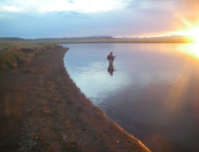
The Yellowtail Dam created a classic tail water fishery that is cold and clear in the summer and ice free in the winter, one of the finest trout streams in the United States.
Rainbow and brown trout are prevalent.
Public access to the Bighorn River is limited to three points on the upper 13 miles of the river: Afterbay, 3 Mile (Lind Ranch) and 13 Mile (Bighorn Access). Fisherman can float and wade the waters of the Bighorn, but are required to stay below the high water mark.
The Bighorn is a gentle cool, clear water river. Though not a challenge to rafters or other whitewater enthusiasts. The loose rocky bottom is lined with mosses and aquatic vegetation making it slippery and quite deceptive, presenting an illusion of shallow water where it may be over ten deep.
The river banks are lined with willow thickets, stands of cottonwood trees, ash, and numerous shrubs.
The land above the high water line is almost entirely in private ownership
Trout populations depend primarily on natural reproduction.
The Bighorn River is one of the most heavily fished streams in Montana.
Fifty years ago the Bighorn was a wild river. Water levels fluctuated drastically with snow melt and rain storms in the Bighorn and Pryor Mountains. Water temperatures could vary from freezing to tepid within a few days. The Bighorn-Wind-Shoshone drainage was laden with tons of sand, silt and gravel. These sediments rendered the Bighorn River unsuitable for a trout fishery.
Construction of the Yellowtail Dam provides irrigation water, flood control, stable water releases and temperatures and sediment deposition in Bighorn Lake resulting in ideal trout habitat.
The Bighorn River has ... developed into a “World Class” blue ribbon trout fishery.
The most frequently caught fish are the brown trout. Rainbow trout are scarce.
A sizeable population of carp is in the river.
IFine trout can be taken at any time of year, even during a snowstorm.
Many different patterns will take fish;
-
Midges hatches occur at any time of the year.
-
Scuds (freshwater shrimp), San Juan Worm, Hares Ear, Muddler Minnows, Pheasant Tail Nymph, and the Zug Bug work well.
-
The Bighorn Special, Wooly Buggers, Dirty Red or Yellow, streaamers work well particularly in the winter months.
-
Various grasshopper patterns produce well fished wet or dry
-
Fishing licenses http://fwp.mt.gov/fish/license/
River Access
Due to Crow Tribal and private land ownership, access to the Bighorn is very limited. The National Park Service maintains public parking and launching facilities at the Afterbay Dam (River Launch) and the 3 mile (Lind) access downstream. The state of Montana maintains the Bighorn Access thirteen miles downstream.
Most anglers drift the river, stopping along the way and fishing likely spots. The river can be waded, as long as you remain below the high water mark, below where terrestrial vegetation ceases. Limited shoreline access exists at the above access points. Trespassing on Crow Tribal or private lands can result in a citation and fines which would spoil your experience on the Bighorn.

While in the area I found avisit to the sire of Custer's last stand a meaningful experience.
If you would like to contribute to the maintenance of this site, please click the button

Rapid River, Maine
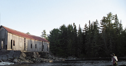
Part of the Androscoggin River system,
Managed by the Rangeley Lakes Heritage Trust,
Accessible to all but requires some hiking, boat travel, or biking to reach the water.
Difficult access helps preserve the quality of the experience.
Provides a thermal refuge for adult brook trout during the hottest part of the summer (July through early September).
...during the spring, summer, and fall, Maine is magic for fly fishers, and the Rapid River is the epitome of that experience.
The...best river in the United States to catch 3- to 5-pound brook trout,
One of the top rivers in Maine to fish for landlocked Atlantic salmon
Flows 31miles to the inlet of Lake Umbagoga
Deboullie Lake, Maine

DEBOULLIE LAKE is 262 acres. Its average depth is-44 feet with a maximum depth of -92 feet.
Principal fisheries are Brook trout and blueback charr.
Common shiners, Redbelly dace, Yellow perch, Creek chubs, Minnows Pearl dace, Lake chubs, White suckers and Golden shiners are also present.
Deboullie Lake is a cold, deep lake especially suited for coldwater game species. Water below the 15-foot level is cold with abundant dissolved oxygen during the warm summer months. Spawning areas for brook trout in Deboullie Lake are chiefly within the lake and in its single inlet tributary. The trout fishery is dependent on natural reproduction and migration from adjoining waters. Deboullie Lake supports a population of the rare blueback charr. Spawning areas for the charr are on the bouldery shoreline within the lake.
Conservative fishing regulations have been implemented to maintain and enhance the sport fishery.
Two-wheel drive access to the lake is via improved gravel road.
Here you can watch a mature bull moose forage along a shoreline and listen to the call of a loon while Fly fishing for native brook trout in one of the last few remaining places in the eastern U.S that anglers still have a chance to pursue trophy trout under such pristine conditions.
Quillayute River WA

The Sol Duc, Bogachiel, Calawah and Dickey converge forming the Quillayute which flows 2 to 3 miles through Olympic National Park before emptying into the Pacific.
Named after Native American people of western Washington the area is known for the Mora and Rialto Beach recreation areas, camping and picnicking facilities, and trailhead access to the coastal wilderness north of the river.

This Trout Bum finds the area worth visiting for its beauty alone. Fishing is a bonus!
Species include Winter and Summer Steelhead, Spring and Fall Chinook, Coho and Chum Salmon and Sea-Run Cutthroat Trout.
THE GOOD NEWS
Every fish bound for the Bogachiel, Sol Duc, and Calawah Rivers has to pass through the Quillayute but…
THE BAD NEWS
…these fish are focused on getting to their home stream and are rarely caught. Holding fish provide most of the action for freshwater salmon and steelhead anglers, not moving fish.

Salmon Run information is provided by the Washington Department of Fish and Wildlife.
Most Quillayute fisherman entice their quarry with salmon eggs, worms, salmon eggs, and sand shrimp.
This is Combat Fishing. Eye protection recommended!
https://en.wikipedia.org/wiki/Quillayute_River
https://liprippersfishing.wordpress.com/2012/12/21/quillayute-river/
Devils Hole Creek, PA


From the archives,Trevor Lanning on Devils Hole.
Fished Devil's Hole Creek at the SGL 221 Access.
Water was low (probably normal for this time of year). Didn't take a temp, but water was running very cold.
Fish were plentiful. caught about six, all browns. Mostly small fish, but some larger fish are in the deeper pools.
Caught them on royal wulffs and small elk hair caddis.
more water and better pools immediately downstream of the access point rather than upstream.
LeTort Spring Run, Carlisle, PA

If your from the Mid Atlantic region, you don’ need me to tell you about LeTort Spring Run. If you aren’t, here are a few items for your consideration.
One of the finest limestone trout streams in the nation, it is known for large wily wild browns. I agree with the book, it is one of the Fifty Places to Fly Fish Before You Die. Aside from the aesthetics, I find it fulfilling to fish where legends have fished. If you are within range of Carlisle, you owe it to yourself to accept the challenge this delightful limestoner presents.
A wonderful opportunity to fish it will be at the Pennsylvania Fly Fishing Museum Association's 17th Annual Heritage Day on Saturday June 8th at 9am.
502 Baltimore Ave, Mt Holly Springs, PA. 17065.
Fly Tyers include: Bob Clouser, Thomas E. Baltz, Brian Shumaker, Henry Ramsay, Bill Skilton, Donald W. Holbrook, Andrew Bogley, John Conrad and more.
Presentations by Bob Clouser, Tom Smithwick, Don Baylor, Brian Shumaker ,and Eric Richard will be fearured.
For more information go to www.paflyfishing.org
Maln Stem, Delaware River
_JPG.jpg)
Puyallup River, Puyallup, WA
![426465_295261203868882_370722921_n[1].jp](https://static.wixstatic.com/media/3bf3fd_0e21c642866043cf9052f9be6094eeba~mv2.jpg/v1/fill/w_300,h_215,al_c,q_80,usm_0.66_1.00_0.01,enc_avif,quality_auto/426465_295261203868882_370722921_n%5B1%5D_jp.jpg)
Rialto Beach, Olympic Penninsula WA

Gibbon River, Yellowstone


Monocacy Creek, Bethlehem, PA

Monocacy Creek (pronounced muh-naw-cuh-see) is one of 56 limestone streams in Pennsylvania.
With headwaters in Pennsylvania’s slate belt near Chapman, there are two sections of special regulation water, both with very good populations of wild Brown Trout.
The first is a 1.9-mile section beginning at state road #987 downstream to state road #248. Classified as "wild trout water" it is regulated as class A.
The second is the two mile long second section of Class A wild trout water starting at the upper end of the Gertrude Fox Conservation Area downstream to Illicks Mill Dam.
As a beginner a got to develop my skills on it’s excellent Trico and Sulphur hatches over fifty years ago.
It was the mid 50’s.
I was on my first bike ride outside of my neighborhood, destination, Monocacy Creek. My first impression was formed by an environmental nightmare, a paint mlll and associated dump,
I biked through the dump to a pool upstream of the carnage and caught my first trout on a fat wiggly worm, The monster was created. Fishing became a lifetime obsession
The stream is now a pristine.tibutary of the Lehigh River.,
The stream has two special regulation sections.
The first, a 1.9-mile section of the creek between state road #987
bridge downstream to the state road #248
Bridge classified as "wild trout water". This section
is regulated as "Class A with a very good population
of wild brown trout.
The second section of Class "A" wild trout regulated
water starts at the upper end of the Fox Gertrude
Conservation Area and extends downstream to the Illicks
Mill Dam. This section is almost two miles long. It too has
a very good population of wild brown trout.
Although it flows through a highly developed area, fly
fishing Monocacy Creek can still be done in a very nice
setting.
Trout can be caught on all but the coldest days of
Winter.ystore.com/wmonacacyc.html
https://en.wikipedia.org/wiki/Monocacy_Creek_(Lehigh_River_tributary)
Monocacy Creek (Lehigh River tributary)
*http://perfectflystore.com/wmonacacyc.html


_JPG.jpg)
It was early in our relationship. My fly fishing bucket list includes Pike. Inspired by one of John Gierachs books, we headed for Spinney. Pike are no longer on Cathy's bucket list, they are still on mine!
On the way back to Camp Rohrbach, during a full moon we turned the CD player all the way up and listened to my friend Julian Robbins in all of his operatic splendor.
Quite a way to start a relationship, eh?


THE BRODHEAD CREEK IS RISING, 1955
Waterways hold an ambivalent fascination for me. Streams provide me with some of my greatest pleasures, but one day a stream can be beautiful and tranquil, hours later it can be cataclysmic.
My love, hate relationship with waterways began in 1955.
Easton Express 8/18/1955

Nancy Johnson after the flood. Easton Express.
Rushing waters demolished about 150 road and rail bridges and breached or destroyed 30 dams. The swollen Brodhead Creek virtually submerged a summer camp, killing 37 people.
Forty-six people, children and their mothers, who were spending five weeks of vacation at the religious camp.
Among them were Jennie Johnson of Jersey City, N.J., and her three children. She was interviewed by The Morning Call on Aug. 22, 1955, and said that around 6:30 p.m. on Aug. 18 she and her children were watching the creek. "We watched the stream rushing past and remarked how pretty it looked. There wasn't anything to worry about, at least we didn't think so then," she said.
They were sitting in the bungalow a half-hour later when the building began to shake. Johnson remembered that it sounded as if a dam had broken. She and her children fled the shaking building for the big, solid home of camp supervisors, the Rev. and Mrs. Leon Davis. There they joined the rest of the campers.
The Davises, who had left earlier to go into town, were not there. Their return had been blocked by the rising water. Although the three-story house seemed safe, water quickly began to rise. As it reached each floor, the screaming campers fled to the next. Finally they were forced to seek refuge in the attic. The campers were watching the water climb the attic stairs after them when the building shuddered and collapsed.
Johnson told The Morning Call she was hit on her head by a board and passed out. When she came to, she found herself floating. Johnson grabbed one board and then another to try to stay afloat. Eventually she drifted onto a debris pile, praying until 7 a.m., when she was rescued. She found her 19-year-old daughter, but her two sons, ages 14 and 10, had died. When the final count was made, only nine of the 46 campers who had been at Camp Davis survived.
______________________________________________
The creek looks pretty said the mother to her sons as the Brodhead Creek was rising
Little David took his mother’s hand, young Roy the other
Mom took them to the big house as the creek continued to rise.
The first floor started flooding.
Mom led the boys to the next floor.
The Brodhead Creek continued to rise.
The water forced them to the attic to seek refuge.
The Brodhead Creek continued to rise.
The rest of the campers all were there.
The women and children all sang hymns.
The creek was still rising.
A wall of water struck the house
The houe started shaking then isintegrated
Mom is swept into the raging torrent, she will never see her sons again.
Daughter Nancy is in a tree, her finger almost gone
Mom is in a debris pile.
Mom and daughter are found alive
Jenny Johnson lived a living purgatory and died of a broken heart
Over 35 relatives and friends died that night
I’ll never fish the Brodhead Creek
THE BRODHEAD CREEK IS RISING, 1955 PART 2
Morning call 8/18/1955
August 18-20, 1955: Three terrifying days and nights still remembered with awe in the Delaware River valley. Record-breaking rainfall from hurricanes Connie and Diane abruptly ended a withering drought, but the relief was short lived. It was soon overshadowed by terror and destruction that tore away bridges and ripped houses from their foundations. From the river’s headwaters in the Catskills and through the Poconos, excessive runoff surged down steep slopes and through valleys on both sides of the river.
Tributaries swelled unbelievably, some rising thirty feet in fifteen minutes. Eventually, they all poured into the Delaware, transforming the usually placid waters into a raging, uncontrollable beast. Mountain resorts were inundated, leaving cars upended in swimming pools. Entire summer camps were washed away. More than 400 children were evacuated by helicopter from island camps in a tense, unprecedented operation.
In the end, nearly a hundred people were dead and hundreds more homeless. Dozens were missing, some ripped, still sleeping, from their beds in the middle of the night. Victims’ bodies were still being recovered thirty years later—some were never found.
“Devastation on the Delaware”
---------------------------------------------------------------------------------------------------------------------
As an infant, Ray Windfield was named, by the orphanage, after the windy field in which he was found.
Ray met a wonderful girl, Edna. They had a son and daughter. Ray was finally living the American dream.
In August 1955, the Brodhead Creek changed all of that. A wall of water swept his family away. He never heard their laughter again.
So much water was flowing out of the Brodhead, the Delaware River actually started to flow north from its confluence with the Brodhead.
As the flood waters subsided, the gruesome search for bodies began. Ray's son and my cousin David s’ bodies couldn’t be found
While houses were still floating down the Delaware, knocking down bridges, my Dad started to organize search parties[A1] . My Dad was that kind of man.
He won the Bronze Star in World War II. His commander had the paperwork for a Silver Star in a briefcase when he and his jeep were blown to smithereens. Dad's army buddies told me of many instances in which he risked his life to save theirs. His explanation to his war time longevity, “God isn’t ready for me to stop doing his work.”
I’ve always been proud of Dad’s wartime heroics but they didn’t top the commitment and focus he exhibited when helping his wife’s family and friends obtain closure.

R. Glenn Rohrbach, (He hated “Rodney.” He thought his name was Glenn until he got in the Army)
.
As an eleven year old, I remember the horror of the phone ringing. Every time it rang there was news of the latest body found.
In spite of Dad's efforts the phone never rang for the Windfield boy or my cousin David.
Through perseverance a young boy's body was delivered to my Aunt Jennie. A funeral was held, the boy we thought was David was buried..
A few days later another young boy was found.
Medical examiners discovered they had mis-identified the first body. We had buried the Windfield boy thinking he was David.
The body was exhumed, a new funeral was held for the Windfield child, and the funeral and burial for David were repeated.
This exceptional country has many unsung heroes. These heroes have done things no one will ever hear about, men who have fought battles they knew they couldn’t win and no one will remember.
There should be someone to tell their stories.
I will never fish the Brodhead Creek.
East Branch, Delaware River


One of the best fishing spots is the Moose River inlet to Big Wood Lake or on the Moose River between Attean and Big Wood.
Cast a line for Brookies from ice out through summer into fall when it becomes catch and release.
Little Lehigh, Pennsylvania

I was a ten year old standing on the deck of the SS United States. My parents brought me to say good bye to a missionary friend.
As sailing time approached we returned to the pier and the fastest passenger liner in the world eased away from the pier. There was music, confetti and cheering.
Born in 1944, the Spring of my life was beginning. Spring for the SS United States began with her maiden voyage in July 1952. and the Little Lehigh was being designated as a TROPHY TROUT STREAM.
Longer than the Titanic, the red stacks of Americas Flagship gleamed, her decks glistened. She was at in the height of her glory, I was gaining fly fishing competence and skillful, lucky anglers were creeling one, twenty inch fish per day on the Little Lehigh.
Four US presidents sailed aboard the SS United States: Harry Truman, Dwight Eisenhower, John Kennedy and Bill Clinton. (The youthful Clinton, fresh out of Georgetown, was on his way to study at Oxford as a Rhodes Scholar.)
I was learning fly fishing from my mentor Steve Kracirovic of Anglers Notch and the Little Lehigh was enjoying the highest population of trout in Pennsylvania,
The SS United States carried an impressive roster of luminaries on nearly every voyage. Famous passengers included Marlon Brando, Coco Chanel, Sean Connery, Gary Cooper, Walter Cronkite, Salvador Dali, Walt Disney, Duke Ellington, Judy Garland, Cary Grant, Charlton Heston, Bob Hope, Marilyn Monroe, Prince Rainier and Grace Kelly, Elizabeth Taylor, John Wayne, and the Duke and Duchess of Windsor.
I got to open a fly shop and fish with Gary Borger, Lefty Kreh, Gary LaFontaine, Ernest Schwiebert, Charlie Meck, Barry & Cathy Beck, Ed Jaworowski, Ed Schenk, Oliver Edwards, Bob Clouser, Jack Gartside, Ed Koch, Don Baylor, A.K. Best, Larry Duckwall and others.
While my favorite ship was setting speed records I was wading the fast water looking with disdain at the sweet water fishermen.
I retired from my shop in 2010.
i couldn’t compete with Cabelas on one siide and LL Bean on the other. Jimmy Carter’s
luxury tax put me out of the fly tying business sending the commercial fly tying tradition over seas.
The SS United States was retired from active service in 1969. The age of the great ocean liners had come to a close, doomed by increasingly fast and affordable trans-Atlantic.
airline flights.
The Little Lehigh began it’s decline with the retirement of Parks Director Don Marushak. The SS United States was drug to Pier 2 in Philadelphia and I began fishing and camping my way around North America.

As people started to talk about selling my favorite ship for scrap, I found stream banks getting higher, the water getting deeper and faster, the rocks more slippery, My loss of balance limiting my fishing opportunities in even the sweetest of water and the great days of the Little Lehigh were beginning to be discussed in the past tense.
Often this Trout Bum has to substitute being where the fish are for fishing. I find fewer opportunity’s to share my knowledge with fishing groups and a deaf ear to efforts to restore my beloved stream. Clubs that tout themselves as stream conservationists, Hall of Fame members and people who have earned a nice living from the resource can’t be bothered. One hero who I got into the sport and helped start his business would rather cut out the tongue of the messenger than do something constructive for his stream.
Now there is talk of restoring the great ship. (http://www.ssusc.org/). I hope they have more success than I’ve been having in efforts to restore the Little Lehigh.
Klickitat River, Washington
Penobscot River, Maine

South Platte, Eleven Mile Canyon, Lake George, CO
Roach River, Kokadjo, Maine


Where can an old guy with limited wading ability go to catch Brook Trout? The Roach River answered the fly shop owner. NOT
A remote tributary of Moosehead Lake, the Roach begins at First Roach Pond at Kokadjo in central Maine…

…and flows about six miles to Spencer Bay
The only catch and release fly fishing only stream in Maine, it is an important spawning area for Brook Trout and Landlocked Salmon.
The Brook trout average about ten inches but go up to three pounds. Landlocked Salmon average about fifteen inches.
Difficult to impossible to fish from the bank. fishing is done wading the named pools.
Find the pools by locating trailheads identified by fisheries department boxes.
This September, I plan to fish The Dam Pool, a deep pool located under the bridge at Kokadjo. The fish from Moosehead Lake tend to hold there. It's easy to access, yet it produces well.
I’ll also explore the Roach ponds.
Harveys Creek, Luzurne County Pennsylvania

It was late evening, I was heading for the Delaware. I picked up a hitch-hiking fisherman. He had a worm caught Palomino over twenty inches.
Worms and Palominos are usually outside my area of interest, but it did bring Harveys Creek to my attention.
When I lived in the Lehigh Valley I fished almost every morning before work. I hoped Harveys Creek would provide the same opportunities. It did provide fishing, but the catching was a different story.
Designated as a High-Quality Coldwater and Migratory water way the creek originates at Harveys Lake and flows 14.5 miles to the Susquehanna River.
The Delayed Harvest area from Jackson Road downstream to Pavlick Road is part of the Keystone Select Stocked Trophy Trout Program.
The creek maintains a reliable flow with plenty of riffles and a consistent tree canopy.
There is good access off Rt. 29 where the bridge crosses on Jackson Road with ample parking.
Little Truckee River, California
Little Truckee River, California

THE LITTLE TRUCKEE RIVER
I purchased my license, found a camp ground in Tahoe National Forrest. and still had a few minutes to fish, which I spent on various forms of snags.
I went to bed looking forward to a full day of fishing the next day.
I woke up and surprise, surprise, the temperature was well below zero.
Even my wine froze.
California’s Little Truckee River is a tailwater emptying in the Truckee River. Located in the Lake Tahoe area it is known to fly fishermen for its 20-inch wild trout in the area between Stampede and Boca Reservoirs.
It can be reached by Stampede Meadow Road off Hwy 80 or by taking Hobart Mills Road from Hwy 89.
The stream is easy to wade but the fish are very selective so as Joe Brooks said, ”wade it before you fish it.”
‘
The best fishing is at the heads of pools, knee deep riffles, and on either the front or back of mid-stream boulders. (the hydraulic cushion)
Long-line Indicator Nymphing is the most consistent way to fish the Little Truckee.
Trout Food (Hatches tend to be disrupted by the periodic water releases from Stampede resovouir)
Dark Winter Stoneflies (Size 16-18)
Little Yellow Stonefly
Caddis
Pale Morning Duns
Green Drakes
Tricos
Bwo's
Terrestrials
Little Green Stoneflies (Size 14-16
Mahogany Duns (Size 14
Sculpins
*Spawning Fish – It is not hard to find fish on their spawning redds during Oct./Nov. and Feb./Mar. in the Little Truckee as the water is gin clear and usually fairly shallow. PLEASE LEAVE THEM ALONE!!!!! Besides the obvious unsportsmanlike nature.
I used Wikipedia and http://renoflyfishingoutfitters.com/ourwaters/little-truckee-river/ to supplement my experience.
Gibbon River

A popular trout fishing destination, the Gibbon River flows east in Yellowstone National Park. It joins the Firehole to become the Madison River.
Named for Colonel John Gibbon,
The upper section of river has very difficult access, brook trout, rainbow trout and grayling on the small side. Any grayling or cutthroat trout caught must be released. An unlimited number of brook, rainbow or brown trout may be harvested above the falls
Below Gibbon Falls access is an excellent, catch and releaase water, It has a healthy mix of rainbow and brown trout with a good run of spawning browns in the fall.
The Yukon River, Alaska

The source of theYukon River is in British Columbia, It flows through theYukon Territory, named after the river. The lower1,980 mi emptys into the Bering Sea at the Yukon–Kuskokwim Delta. The total drainage area is 25% larger than Texas.
I accessed it via the Dalton Highway (the Ice Road Truckers Road,)
a rough road that begins 84 miles north of Fairbanks and ends 414 miles later in Deadhorse at Prudhoe Bay. It provides a rare opportunity to traverse a remote, unpopulated part of Alaska to the very top of the continent.
The Dalton Highway beckons adventurous souls to explore a still-wild and mysterious frontier a harsh land, a special part of our world.
There are no public services, medical facilities, banks, ATM machines, grocery stores or cell phone coverage from Elliott Highway Milepost 28 until just outside of Deadhorse.
Are the bugs really that bad? YES! Hordes of mosquitoes emerge in mid-June and last into August. A head net and bug jacket are essential if you plan on any outdoor activities.
The Pohopoco, Monroe and Carbon Counties, Penna

Pennsylvania's Pohopoco Creek, aka Big Creek, is both the headwater and tailwater of Beltzville Lake. The 27.8 miles long creek flows through Carbon and Monroe counties.
From SR 3016 to Rt 209 its rated Class A
Further downstream Old Mill Road takes you to the base of the dam plenty of parking, a USGS Gauging Station, a low head dam and lots of masterbaiters.
The Pohopoco enters the Lehigh River just a few hundred yards from Parryville near 248
.
The Pohopoco is one of a few streams to have an impact on the daily life of the White Haven Rohrbachs. One of my Big Creek fishing trips resulted in the purchase of my sons goat ZONKER.

The following is an article from the Little Lehigh Fly Shop archves. It was written in the 90's. I'm anxious to return this year and see how it has changed.
The Pohopoco, (Big Creek)
The Pohopoco first caught my interest years ago when I was a banker. I was doing buisness well upstream at a place the stream passes over route 115. Big Lakers were stacked up like cord wood on that October day.
When I want to learn about a stream I go to Charlie Meck's book or the book by Dwight Landis. But the Pennsylvania stream authority I respect the most is Don Douple. I've fished with many fly fishing legends. Don takes a back seat to none of them. His knowledge of Pennsylvania streams is nothing less than extraordinary. He is also a wizard with a fly rod. If you want to learn about trout, listen to Don whenever you have the opportunity. Most of the information in this articled was gleaned from Don's fertile mind.
The Pohopoco begins near Merwinsburg. The portion between Merwinsburg and Effort holds wild Browns and Brookies. Their is thick Rododendron and some posted areas.
The stretch between Effort and Gilbert is about 20 feet wide. It is small and brushy with lots of weeds and some posting. This area holds wild Browns as well as some Brooks and Bows. Springs in the Gilbert area provide cold water.
As the water flows to its confluence with Dotters Creek (near Kresgeville) it is slow, brushy and swampy with a soft bottom. Although difficult to wade, the effort is worthwhile as this area holds some big Trout.
Don caught seven species of fish, on a fly, in one day here. (Browns, Rainbows, Largemouth Bass, Fallfish,
Yellow Perch, Sunfish and Brook Trout.)
In the the Gilbert area, the stream is about 20 feet wide From it's confluence with Dotters to the Beltzville dam the stream isn't stocked by the Pennsylvania Fish and Boat Commission due to the outstanding wild trout population. There is scattered posting and limited parking.
The stream consists of riffles, runs and pools.
Jack Reichelderfer, was one of my favorite storytellers, told me of 9 pound Browns in in the lake, but the lake should be the subject of it's own article.
Between the Beltzville Dam and the dam at Parryville the stream is mostly open with some posting. There are wild Browns here. Some are large but most are 10 inchers. This stretch is also stocked by the PF&BC. If there is a major flood, the commercial hatchery's lose trout to Big Creek. There is very little parking here except for the area of the turnpike and below the dam. Be prepared to walk!
From Parryville dam upstream to Route 209 at the turnpike the stream is posted.
Fish the area from the dam at Parryville to the confluence with the Lehigh River for the wild Browns and fish from the Lehigh River that enter the river to take advantage of the cooler water in the summer and warmer water in the winter. This phenominon occurs thanks to the bottom release feature of Beltzville Dam. This stretch is fishable in winter and open during the extended season.
Main hatches are:
Hendricksons in April
Caddis in May
Isonycia (Slate Drakes) and terrestrials throughout the summer.
Give Big Creek a try. You'll like it!

These are the headwaters of the Arkansas River near Leadville, CO. A major tributary of the Mississippi River, it flows east through Kansas, Oklahoma to Napoleon, Arkansas. It is the sixth-longest river in the United States.
The waters of the Arkansas are prime territory for browns that love to feast on the massive caddis hatches, especially along the stretch of river that runs from Brown’s Canyon to the Royal Gorge ( one of the deepest canyons and one of the best views in all of Colorado.)
Floating is popular for anglers who visit the Arkansas.
Recreational rafters appear at mid day and can be avoided by fishing in the morning and evening or heading up stream.
There are numerous outfitters in Salida and Buena Vista. The folks in the Leadville office of the National Park service are helpful.
The Arkansas is thirty years out from a massive clean up. While not being known for large browns or gigantic rainbows, it is known for its massive population numbers.
I find the people in this area cordial, the scenery beautiful with interesting fish able tributarys and trout bum camping opportunities plentiful.
White Deer Creek' Woap'-achtu-hanne, Pennsylvania


White Deer Creek is freestone, forrested, stocked, high-quality, Coldwater Fishery and a Migratory Fishery, Brook Trout and Brown Trout live there.
A tributary of the West Branch Susquehanna River it flows alongside Interstate 80,
Much of the length of White Deer Creek is in Bald Eagle State Forest it also passes through McCalls Dam State Park.
At the suggestion of Bob Laubach (R B Winter TU) I spent a day there on my way to Alaska.
I was serenaded to sleep by two of my favorite performers, Whippoorwills and Peepers.
Dorotheas were present.
I saw more bears in one day than on any day on my round trip to the Arctic Circle
DELIGHTFUL!
Yampa River, Steamboat Springs, Colorado
Yellow Creek
iis in Indiana County near Homer City Pennsylvania. It is Approved Trout Water.
Little Yellow Creek and Laurel Run are tributarys and are also Approved Trout Water.
Part of Yellow Creek runs through Yellow Creek State Park at which camping is available.

Colorado River


Payette River, Idaho

The Madison

Maine's Kennebeck

Brooks Range between Cold Foot and Prudhoe Bay, Alaska

The Hosensack, Eastern Pennsylvania

The Firehole, Yellowstone National Park

Fishing Creek, Lamar, Penna.
